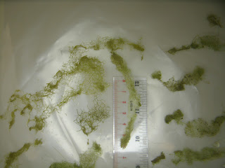
The Wabash River is abnormally low due to the many weeks of dry weather. The algae growing here in this shallow slow-current spot is Hydrodictyon, sometimes called Water Net. It has a characteristic yellow-green color when viewed from a distance like this. This is near the boat ramp at Mascouten Park in West Lafayette. The Wabash River water level as measured at the Lafayette gauging station is 1.61 feet. All pictures taken July 7, 2012.
Link to Wabash River levels:
A closer look at the Hydrodictyon in the Wabash River. The cells of this algae are linked together in a net pattern.
Link to Hydrodictyon:
Hydrodictyon forms these net tubes about a centimeter wide.
Link to Hydrodictyon:
An even closer look at the Hydrodictyon cell structure. Each scale division is one millimeter.
REVISION July 23, 2012: It seems that the Lafayette gauging station was recalibrated soon after this picture was taken, the corrected water level on this day would have been something like 1.0 feet.
Tuesday, July 10, 2012
Subscribe to:
Post Comments (Atom)


No comments:
Post a Comment